

| The World Factbook | ||
|
|
Saint Lucia |
|
|
| Introduction | Saint Lucia |
|
Background:
|
The island, with its fine natural harbor at Castries, was contested between England and France throughout the 17th and early 18th centuries (changing possession 14 times); it was finally ceded to the UK in 1814. Even after the abolition of slavery on its plantations in 1834, Saint Lucia remained an agricultural island, dedicated to producing tropical commodity crops. Self-government was granted in 1967 and independence in 1979. |
| Geography | Saint Lucia |
|
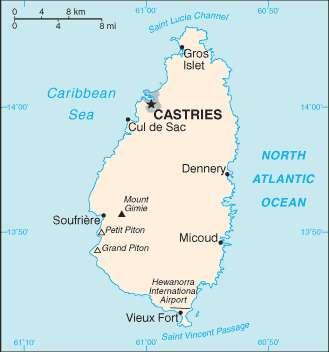
Location:
|
Caribbean, island between the Caribbean Sea and North Atlantic Ocean, north of Trinidad and Tobago |
|
Geographic coordinates:
|
13 53 N, 60 58 W |
|
Map references:
|
Central America and the Caribbean |
|
Area:
|
total: 616 sq km
land: 606 sq km water: 10 sq km |
|
Area - comparative:
|
3.5 times the size of Washington, DC |
|
Land boundaries:
|
0 km |
|
Coastline:
|
158 km |
|
Maritime claims:
|
territorial sea: 12 nm
contiguous zone: 24 nm exclusive economic zone: 200 nm continental shelf: 200 nm or to the edge of the continental margin |
|
Climate:
|
tropical, moderated by northeast trade winds; dry season January to April, rainy season May to August |
|
Terrain:
|
volcanic and mountainous with some broad, fertile valleys |
|
Elevation extremes:
|
lowest point: Caribbean Sea 0 m
highest point: Mount Gimie 950 m |
|
Natural resources:
|
forests, sandy beaches, minerals (pumice), mineral springs, geothermal potential |
|
Land use:
|
arable land: 6.45%
permanent crops: 22.58% other: 70.97% (2005) |
|
Irrigated land:
|
30 sq km (2003) |
|
Natural hazards:
|
hurricanes and volcanic activity |
|
Environment - current issues:
|
deforestation; soil erosion, particularly in the northern region |
|
Environment - international agreements:
|
party to: Biodiversity, Climate Change, Climate Change-Kyoto Protocol, Desertification, Endangered Species, Environmental Modification, Hazardous Wastes, Law of the Sea, Marine Dumping, Ozone Layer Protection, Ship Pollution, Whaling
signed, but not ratified: none of the selected agreements |
|
Geography - note:
|
the twin Pitons (Gros Piton and Petit Piton), striking cone-shaped peaks south of Soufriere, are one of the scenic natural highlights of the Caribbean |
| People | Saint Lucia |
|
Population:
|
168,458 (July 2006 est.) |
|
Age structure:
|
0-14 years: 29.8% (male 25,941/female 24,319)
15-64 years: 65% (male 53,916/female 55,582) 65 years and over: 5.2% (male 3,186/female 5,514) (2006 est.) |
|
Median age:
|
total: 25.2 years
male: 24.4 years female: 26.1 years (2006 est.) |
|
Population growth rate:
|
1.29% (2006 est.) |
|
Birth rate:
|
19.68 births/1,000 population (2006 est.) |
|
Death rate:
|
5.08 deaths/1,000 population (2006 est.) |
|
Net migration rate:
|
-1.73 migrant(s)/1,000 population (2006 est.) |
|
Sex ratio:
|
at birth: 1.07 male(s)/female
under 15 years: 1.07 male(s)/female 15-64 years: 0.97 male(s)/female 65 years and over: 0.58 male(s)/female total population: 0.97 male(s)/female (2006 est.) |
|
Infant mortality rate:
|
total: 13.17 deaths/1,000 live births
male: 14.29 deaths/1,000 live births female: 11.97 deaths/1,000 live births (2006 est.) |
|
Life expectancy at birth:
|
total population: 73.84 years
male: 70.29 years female: 77.65 years (2006 est.) |
|
Total fertility rate:
|
2.18 children born/woman (2006 est.) |
|
HIV/AIDS - adult prevalence rate:
|
NA |
|
HIV/AIDS - people living with HIV/AIDS:
|
NA |
|
HIV/AIDS - deaths:
|
NA |
|
Nationality:
|
noun: Saint Lucian(s)
adjective: Saint Lucian |
|
Ethnic groups:
|
black 90%, mixed 6%, East Indian 3%, white 1% |
|
Religions:
|
Roman Catholic 67.5%, Seventh Day Adventist 8.5%, Pentecostal 5.7%, Anglican 2%, Evangelical 2%, other Christian 5.1%, Rastafarian 2.1%, other 1.1%, unspecified 1.5%, none 4.5% (2001 census) |
|
Languages:
|
English (official), French patois |
|
Literacy:
|
definition: age 15 and over has ever attended school
total population: 90.1% male: 89.5% female: 90.6% (2001 est.) |
| Government | Saint Lucia |
|
Country name:
|
conventional long form: none
conventional short form: Saint Lucia local long form: none local short form: Saint Lucia |
|
Government type:
|
parliamentary democracy |
|
Capital:
|
name: Castries
geographic coordinates: 14 01 N, 61 00 W time difference: UTC-4 (1 hour ahead of Washington, DC during Standard Time) |
|
Administrative divisions:
|
11 quarters; Anse-la-Raye, Castries, Choiseul, Dauphin, Dennery, Gros-Islet, Laborie, Micoud, Praslin, Soufriere, Vieux-Fort |
|
Independence:
|
22 February 1979 (from UK) |
|
National holiday:
|
Independence Day, 22 February (1979) |
|
Constitution:
|
22 February 1979 |
|
Legal system:
|
based on English common law |
|
Suffrage:
|
18 years of age; universal |
|
Executive branch:
|
chief of state: Queen ELIZABETH II (since 6 February 1952), represented by Governor General Dame Pearlette LOUISY (since September 1997)
head of government: Prime Minister Kenneth Davis ANTHONY (since 24 May 1997) and Deputy Prime Minister Mario MICHEL (since 24 May 1997) cabinet: Cabinet appointed by the governor general on the advice of the prime minister elections: none; the monarch is hereditary; the governor general is appointed by the monarch; following legislative elections, the leader of the majority party or the leader of a majority coalition is usually appointed prime minister by the governor general; deputy prime minister appointed by the governor general |
|
Legislative branch:
|
bicameral Parliament consists of the Senate (11 seats; 6 members appointed on the advice of the prime minister, 3 on the advice of the leader of the opposition, and 2 after consultation with religious, economic, and social groups) and the House of Assembly (17 seats; members are elected by popular vote from single-member constituencies to serve five-year terms)
elections: House of Assembly - last held 3 December 2001 (next to be held in December 2006) election results: House of Assembly - percent of vote by party - SLP 55%, UWP 37%, NA 3.5%; seats by party - SLP 14, UWP 3 |
|
Judicial branch:
|
Eastern Caribbean Supreme Court (jurisdiction extends to Anguilla, Antigua and Barbuda, the British Virgin Islands, Dominica, Grenada, Montserrat, Saint Kitts and Nevis, Saint Lucia, and Saint Vincent and the Grenadines) |
|
Political parties and leaders:
|
National Alliance or NA [George ODLUM]; Saint Lucia Freedom Party or SFP [Martinus FRANCOIS]; Saint Lucia Labor Party or SLP [Kenneth ANTHONY]; Sou Tout Apwe Fete Fini or STAFF [Christopher HUNTE]; United Workers Party or UWP [Sir John COMPTON] |
|
Political pressure groups and leaders:
|
NA |
|
International organization participation:
|
ACCT, ACP, C, Caricom, CDB, FAO, G-77, IBRD, ICAO, ICCt (signatory), ICFTU, ICRM, IDA, IFAD, IFC, IFRCS, ILO, IMF, IMO, Interpol, IOC, ISO, ITU, MIGA, NAM, OAS, OECS, OIF, OPANAL, OPCW, UN, UNCTAD, UNESCO, UNIDO, UPU, WCL, WCO, WFTU, WHO, WIPO, WMO, WTO |
|
Diplomatic representation in the US:
|
chief of mission: Ambassador Sonia Merlyn JOHNNY
chancery: 3216 New Mexico Avenue NW, Washington, DC 20016 telephone: [1] (202) 364-6792 through 6795 FAX: [1] (202) 364-6723 consulate(s) general: Miami, New York |
|
Diplomatic representation from the US:
|
the US does not have an embassy in Saint Lucia; the US Ambassador to Barbados is accredited to Saint Lucia |
|
Flag description:
|
blue, with a gold isosceles triangle below a black arrowhead; the upper edges of the arrowhead have a white border |
| Economy | Saint Lucia |
|
Economy - overview:
|
Changes in the EU import preference regime and the increased competition from Latin American bananas have made economic diversification increasingly important in Saint Lucia. The island nation has been able to attract foreign business and investment, especially in its offshore banking and tourism industries. The manufacturing sector is the most diverse in the Eastern Caribbean area, and the government is trying to revitalize the banana industry. Economic fundamentals remain solid, even though unemployment needs to be cut. |
|
GDP (purchasing power parity):
|
$866 million (2002 est.) |
|
GDP (official exchange rate):
|
NA |
|
GDP - real growth rate:
|
3.3% (2002 est.) |
|
GDP - per capita (PPP):
|
$5,400 (2002 est.) |
|
GDP - composition by sector:
|
agriculture: 7%
industry: 20% services: 73% (2002 est.) |
|
Labor force:
|
43,800 (2001 est.) |
|
Labor force - by occupation:
|
agriculture: 21.7%
industry: 24.7% services: 53.6% (2002 est.) |
|
Unemployment rate:
|
20% (2003 est.) |
|
Population below poverty line:
|
NA% |
|
Household income or consumption by percentage share:
|
lowest 10%: NA%
highest 10%: NA% |
|
Inflation rate (consumer prices):
|
3% (2001 est.) |
|
Budget:
|
revenues: $141.2 million
expenditures: $146.7 million; including capital expenditures of $25.1 million (2000 est.) |
|
Agriculture - products:
|
bananas, coconuts, vegetables, citrus, root crops, cocoa |
|
Industries:
|
clothing, assembly of electronic components, beverages, corrugated cardboard boxes, tourism; lime processing, coconut processing |
|
Industrial production growth rate:
|
-8.9% (1997 est.) |
|
Electricity - production:
|
281 million kWh (2003) |
|
Electricity - production by source:
|
fossil fuel: 100%
hydro: 0% nuclear: 0% other: 0% (2001) |
|
Electricity - consumption:
|
261.4 million kWh (2003) |
|
Electricity - exports:
|
0 kWh (2003) |
|
Electricity - imports:
|
0 kWh (2003) |
|
Oil - production:
|
0 bbl/day (2003 est.) |
|
Oil - consumption:
|
2,520 bbl/day (2003 est.) |
|
Oil - exports:
|
NA bbl/day |
|
Oil - imports:
|
NA bbl/day |
|
Natural gas - production:
|
0 cu m (2003 est.) |
|
Natural gas - consumption:
|
0 cu m (2003 est.) |
|
Exports:
|
$82 million (2004 est.) |
|
Exports - commodities:
|
bananas 41%, clothing, cocoa, vegetables, fruits, coconut oil |
|
Exports - partners:
|
France 29.5%, US 17.6%, China 17.1%, UK 13.2%, Brazil 6.3% (2005) |
|
Imports:
|
$410 million (2004 est.) |
|
Imports - commodities:
|
food 23%, manufactured goods 21%, machinery and transportation equipment 19%, chemicals, fuels |
|
Imports - partners:
|
US 24.2%, Trinidad and Tobago 15.6%, Netherlands 14.5%, Venezuela 5.6%, UK 5.6%, France 4.7% (2005) |
|
Debt - external:
|
$214 million (2000) |
|
Economic aid - recipient:
|
$51.8 million (1995) |
|
Currency (code):
|
East Caribbean dollar (XCD) |
|
Currency code:
|
XCD |
|
Exchange rates:
|
East Caribbean dollars per US dollar - 2.7 (2005), 2.7 (2004), 2.7 (2003), 2.7 (2002), 2.7 (2001) |
|
Fiscal year:
|
1 April - 31 March |
| Communications | Saint Lucia |
|
Telephones - main lines in use:
|
51,100 (2002) |
|
Telephones - mobile cellular:
|
93,000 (2004) |
|
Telephone system:
|
general assessment: adequate system
domestic: system is automatically switched international: country code - 1-758; direct microwave radio relay link with Martinique and Saint Vincent and the Grenadines; tropospheric scatter to Barbados; international calls beyond these countries are carried by Intelsat from Martinique |
|
Radio broadcast stations:
|
AM 2, FM 7, shortwave 0 (2004) |
|
Radios:
|
111,000 (1997) |
|
Television broadcast stations:
|
2 (of which one is a commercial broadcast station and one is a community antenna television or CATV channel) (2004) |
|
Televisions:
|
32,000 (1997) |
|
Internet country code:
|
.lc |
|
Internet hosts:
|
25 (2005) |
|
Internet Service Providers (ISPs):
|
15 (2000) |
|
Internet users:
|
55,000 (2005) |
| Transportation | Saint Lucia |
|
Airports:
|
2 (2006) |
|
Airports - with paved runways:
|
total: 2
2,438 to 3,047 m: 1 1,524 to 2,437 m: 1 (2006) |
|
Roadways:
|
total: 910 km
paved: 48 km unpaved: 862 km (2000) |
|
Ports and terminals:
|
Castries, Cul-de-Sac, Vieux-Fort |
| Military | Saint Lucia |
|
Military branches:
|
no regular military forces; Royal Saint Lucia Police Force (includes Special Service Unit, Coast Guard) (2006) |
|
Manpower available for military service:
|
males age 18-49: 42,742 (2005 est.) |
|
Manpower fit for military service:
|
males age 18-49: 33,539 (2005 est.) |
|
Manpower reaching military service age annually:
|
males age 18-49: 1,651 (2005 est.) |
|
Military expenditures - dollar figure:
|
NA |
|
Military expenditures - percent of GDP:
|
NA |
| Transnational Issues | Saint Lucia |
|
Disputes - international:
|
joins other Caribbean states to counter Venezuela's claim that Aves Island sustains human habitation, a criterion under UNCLOS, which permits Venezuela to extend its EEZ/continental shelf over a large portion of the Caribbean Sea |
|
Illicit drugs:
|
transit point for South American drugs destined for the US and Europe |
|
This page was last updated on 19 September, 2006 |